Phang-Nga Province in Southern Thailand

Phang-nga, land of tin mines and beautiful scenery, is nestled among mountains which rise up around the town like a town wall. The majority of the area is mountainous with very little basin area. Phangnga covers the area of 4,170.90 sq.km., 57% of which is mangrove and evergreen forest.
Phang-nga is 788 kms. from Bangkok, bordering on Ranong to the north, Phuket to the south, Krabi and Surat Thani to the east, and the Andaman Sea to the west. It is administratively divided into eight Amphoes : Muang, Kapong,Khura Buri, Takua Pa,Takua Thung, Thai Muang, ThapPut and Ko Yao.
What to see and what to do in Phang-Nga?
Directory Listings : Hotels and Resorts in Phang-Nga
Tham Sawan Khuha cave is located in Amphoe Takua Thung, 7 kms. before arriving in the Phangnga. The cave is a part of Wat Suwan Khuha (or Wat Tham) and houses Buddha images, prangs and pagodas. There a lot of beautiful stalactites and stalagmites.
Tham Phung Chang cave is located on Khao Chang behind the provincial prison. Replicas of famous Buddha images are housed in this beautiful cave, in addition to strange stalactite and stalagmite formations.
Ao Phangnga National Park is located in Arnphoe Muang, Arnphoe Takua Thung and Amphoe Ko Yao of Phangnga. The park covers an area of 400 square kilometers, mainly comprised of many isles of different shapes and sizes. Caves and beautiful bays together with rock formations and mangrove are some of the park's major attractions. From Ao Phangnga, there are tour boat services at Tria Dan Pier in Amphoe Muang and at Surakun Pier in Amphoe Takua Thung There are;
Phang-Nga bay
Khao Khan
Here, in a mountain cavern, primitive paintings depicting fish, water lizards and dolphins which are believed to be several thousand years old.
Ko Panyi
On this island is an entire Thai Muslim fishing village of about 500 households built on stilts in the sea and connected by wooden bridges. There is one school in the village and a plot of land with a mosque and burial ground.
Ko Nom Sao
These twin islands, also called Ko Ok Meri, are located nearby Ko Panyi.
Ko Talu
This island is just beyond Ko Nom Sao. The middle part of it has been eroded by water and boats pass among giant stalactites through a water-filled cavern from one side of the island to the other .
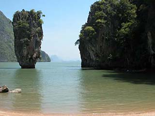
Ko Khao Ping Zan
Here is a spectacular high cliff that appears to have been cut in two. The halves are supported by leaning against each other. It is a sight of rare and exquisite beauty.
Ko Tapa,
"Nail Island" in English, is a small island located in front of Khao Ping Kan. The base is quite narrow but it has a broad peak, giving the strange and beautiful appearance of a spike driven into the sea.
Tham Lot This cave is another spot of interest in the Ao Phangnga area. It is similar in appearance but larger than Ko Talu. The mouth of the cave is about 50 meters wide, 40 meters high and small boats may pass through. There are beautiful stalactites inside the cave which is length of about 100 meters in length.
Khao Machu
On a hilltop, there is a rock formation resembling a crow.
Ko Yao covers an area of 137.6 square kilometers consisting of 2 main islands: Ko Yao Noi and Ko Yao Yai and several surrounding islets. Beautiful beaches include: Hat Pa Sai, Hat Tha Khao, Ao Tikut, Ao Khlong Son and Hat Lopareat. To get to Ko Yao Tram Ao Phangnga pier takes about 2 hours. Boats are also available from Ao Po, Phuket, the trip takes about 1 1/2 hours.
Khao Lampi-Hat Thai Muang National Park covers an area of 72 square kilometers and was proclaimed a national park on April 14, 1986. Places of interest in this national park are:
Hat Thai Muang
This is located in Thai Muang Sanitary area where a 1.5 kilometer asphalt road branches off on the right to join the beach road for another five kilometers to reach the office of the national park. Thai Muang Beach is a 13 kilometer clean, sandy beach with clear water. From November to February, sea turtles will come up to the beach to lay eggs.
Khao Lak-Lam Ru National Park, Khao Lak-Lam Ru, covers a total area of some 125 square kilometer of Amphoe Thai Muang, Amphoe Ka Pong, Amphoe Ta Kua Pa and Amphoe Muang. It consists of the following attractions:
Khao Lak
Taking the route No.4 (Thai Muang-Ta Kua Pa) for 25 kilometers from Amphoe Ta Kua Pa then turning left between KM.56-57, Khao Lak Mountain with a shrine of Chao Pho Khao Lak is situated opposite the Khao Lak Seashore, renowned for its stony beach.
Lam Ru Waterfall is a 5-tiered, year-round waterfall in Kradai Range, Lam Ru Waterfall is accessible by a branch road off the Highway No.4090 with a 1-kilometer turn to the falls.
Mu Ko Surin National Park is located in the Andaman Sea and covers an area of approximately 135 square kilometers. To reach this five islets archipelago, tourists may start from three different point, but the most convenience and the shortest is from Ban Hin Lat in Amphoe Khura Buri which takes about 4-5 hours. The islands' attractions are long, beautiful beaches with smooth white sand, lines of perfect coral reef and mainland inhabited by sea gypsies. Note for the most suitable time to visit is from December-March of each year.
Mu Ko Similan National Park occupies an area of approximately 130 square kilometres. To get to the park, one can take a boat trip from the pier in Tambon Thap Lamu, Amphoe Takua Pa or from the pier in Amphoe Khura Buri. The trip takes about three hours. Similan, a small archipelago in the Andaman Sea, is comprised of nine islands. It is famous for both surface and under water beautiful scenery. The best time to make a trip for diving and angling is from late December to mid April.
Si Phangnga National Park, situated in Amphoe Khura Buri, 100 kilometers to the north of the provincial town, covers an area of about 246.08 square kilometers. The park was established in honor of His Majesty the King on his 60th birthday. This forested piece of land is home to large variety of flora and fauna. Places of interest within the park are Tam Nang Waterfall, Ton Toei Waterfall and Ton Ton Sai Waterfall.