Tak Province in Northern Thailand
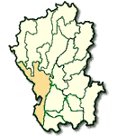
Tak is a province that is important for the economy of Northern Thailand. It is a communication center to the North having the Asian Highway passing through the Myanmar-Thai border into Thailand at Amphoe Mae Sot, then to Sukhothai, Phitsanulok towards Northeastern Thailand entering Laos at Chong Mek pass of Ubon Ratchathani.Tak is the site of Bhumibol Dam, the largest in Thailand. It covers an area of 16,406.6 square kilometers. Tak is located 426 kms. from Bangkok and is administratively divided into 8 Amphoes: Muang, Ban Tak, Mae Ramat, Mae Sot, Pho Phra, Sam Ngao, Tha Song Yang and Umphang
What to see and what to do in Tak?
Lan Sang National Park is located on Tak - Mae Sot Highway at Km. 12 - 13, where a 3 kms. access road leading to the park branches off on the left. In the park one can see beautiful falls such as Lan Sang Waterfall, Pha Phung Waterfall and Lan Liang Ma Waterfall. The general surroundings are shady and suitable for relaxation. Tak residents like to spend their holidays there.
Khao Tham is a famous tourist attraction of Changwat Tak, located at Tambon Mai Ngam, Amphoe Muang, and is accessible via a 300 meter branch road off Phahonyothin Road. Its features a 71 meter high hill having big rocks beautifully dotting the area. One can access the hilltop via a hiking path. A replica of Lord Buddha's Footprints is enshrined on top the hill. There Tak residents like to pay their homage by affixing gold leave to the footprints during the Songkran Festival.
Wat Phra Boromthat and Ancient Tak City monastery is located 25 kms. north of the township area. This area used to be the site of old Tak town. There are still several ruins of town and monasteries to be seen. Especially on top of a hill near Wat Phrathat, there is a pagoda of Phum Khao Binth design. Legend says this pagoda was constructed on the order of King Ramkhamhaeng to honor his victory in a single hand combat on the elephant's back against King Khun Sam Chon (the ruler of Muang Chot currently Amphoe Mae Sot).
Bhumibol Dam is the largest dam in Thailand. It blocks the Mae Ping River at Amphoe Sam Ngao. Started in 1953, it was completed in May 1964. Its a height, from rock foundation to the top of the barrier, is 245 meters thus providing a reservoir capacity of 12,200 million cubic meters or equivalent to 308 square kilometers. Besides agricultural benefits, flood prevention, generating electric power, it is now noted for cruising trips made from the dam site to Amphoe Hot.
Cruising along the Mae Ping Lake
This boat or raft cruise is made through the upstream area of the lake from Bhumibol Dam to Doi Tao of Chiang Mai, a distance of 140 kms.
Taksin Maharat National Park was originally named Krabak-Yai National Park after Thailand's biggest tree. The park is located along Tak-Mae Sot Highway (No.105) about km. 25-26, with the access a 2 kms. road on the right leading to the park. With the area of 149 square kilometers or 37,250 acres, the park is surrounded by steep mountains and hills. It has shady trees, evergreen forest, waterfalls, clear streams and many beautiful view points. Accommodations are provided in the form of bungalows, tents and tourist-houses. Reservation can be made through the National Park Division Tel. 5790529, 5794842.
Hill-tribes Produces Stalls, located at km. 29 on Tak-Mae Sot route, sell various crops of Hill-tribes people from morning until afternoon.
Pha Charoen Waterfall is a breathtaking 97-tiered waterfall located between Kilometers 36-37 along Highway 1090. After turning left to a dirt road off the highway, drive further for 700 meters to reach Pha Charoen Waterfall.
Amphoe Umphang is also a border district adjoining Myanmar. It is about 249 kilometers from the provincial city along the Highway 105 on the Tak-Mae Sot route, with a turn to the Mae Sot-Um Phang Highway (Highway 1090). The road meanders through mountains to Amphoe Um Phang. Another former Karen settlement, the district was later inhabited by migrant people from northern Thailand. Nowadays, Amphoe Um Phang is renowned for its challenging activities like jungle trekking and rafting. This is thanks to its intact natural environment.
Tourist Attraction in Amphoe Umphang include :
'Doi Hua Mot' where scenic sunrise and the sea of the morning mist, as well as, sunset are not to be missed. Tham Ta Ko Bi is a spacious cave with beautiful stalagmites and stalactites. 'Mu Ban Karieng Pa La Tha' is an authentic Karen village where the villagers still dress in their original costumes. Thi Lo Su Waterfall is a large breathtaking water fall cascading down a high cliff with streaming water all year round.